
iOS实现百度地图定位签到功能
写在前面:
项目需求用到这个功能,主要目的是实现老师设置位置签到范围,学生在一定范围内进行签到的功能。
功能如下方截图:
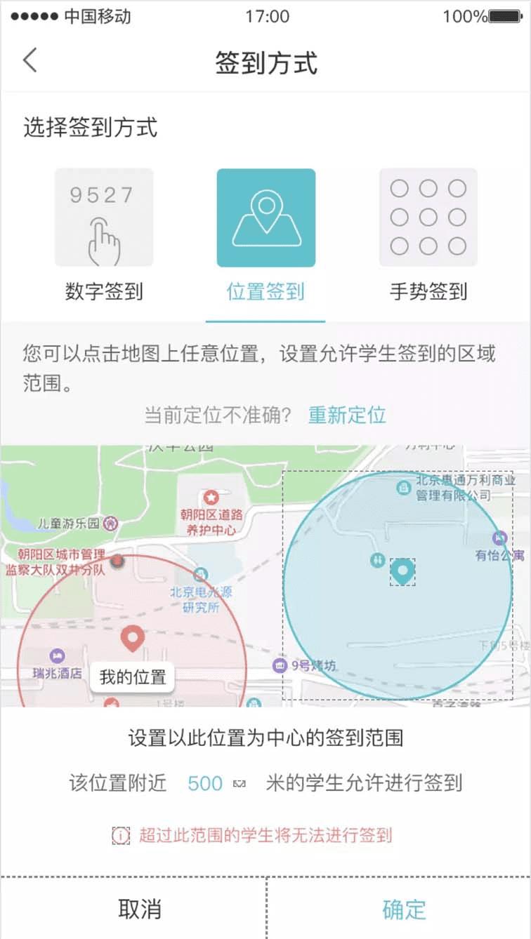
屏幕快照 2019-01-28 上午10.29.26.png
简要介绍:
下面记录一下主要的实现流程,功能的实现主要是根据百度地图开发者官网提供的api文档,各项功能之间组合。百度地图的SDK现在分成了地图功能和定位功能两块不同的SDK,BaiduMapAPI这个是基础的地图功能,BMKLocationKit这个是定位功能。项目里实现定位签到功能用的的SDK包括上面说的这两个模块,所以在用cocopods引入framework的时候,需要引入: #百度地图 pod 'BMKLocationKit' pod 'BaiduMapKit'
功能实现
一、在APPdelegate.m文件中引入:
#import <BaiduMapAPI_Base/BMKBaseComponent.h>
#import <BMKLocationKit/BMKLocationComponent.h>
加入功能代码:
#pragma mark 百度地图设置
- (void)configBaiduMap {
 NSString *ak = @"xxxx";
 BMKMapManager *mapManager = [[BMKMapManager alloc] init];
 self.mapManager = mapManager;
 BOOL ret = [mapManager start:ak generalDelegate:nil];
 [[BMKLocationAuth sharedInstance] checkPermisionWithKey:ak authDelegate:self];
 if (!ret) {
  NSLog(@"manager start failed!");
 }
}
二、在用到地图定位功能的viewController中
#import <BMKLocationKit/BMKLocationComponent.h>
#import <BaiduMapAPI_Base/BMKBaseComponent.h>//引入base相关所有的头文件
#import <BaiduMapAPI_Map/BMKMapComponent.h>//引入地图功能所有的头文件
遵循协议<BMKMapViewDelegate,BMKLocationManagerDelegate>
声明全局变量
@property (nonatomic, strong) BMKUserLocation *userLocation; //当前位置对象
@property (nonatomic, strong) BMKLocationManager *locationManager;/** locationManager*/
@property (nonatomic, strong) BMKMapView *mapView;/** 百度地图*/
//@property (nonatomic, strong) BMKPointAnnotation* annotation ;/** 标记*/
@property (nonatomic, strong) NSMutableArray *annotationArr;/** 标记数组*/
@property (nonatomic, strong) NSMutableArray *circleArr;/** 圆形数组*/
地图SDK文档中建议在以下代码中如此设置, 目的是控制内存
- (void)viewWillAppear:(BOOL)animated {
 [super viewWillAppear:animated];
 [_mapView viewWillAppear];
 _mapView.delegate = self;
}

- (void)viewWillDisappear:(BOOL)animated {
 [super viewWillDisappear:animated];
 [_mapView viewWillDisappear];
 _mapView.delegate = nil;
}

- (void)dealloc {
 if (_mapView) {
  _mapView = nil;
 }
}
初始化数组,这两个数组在接下来会用到
- (NSMutableArray *)annotationArr {

 if (!_annotationArr) {
  _annotationArr = [NSMutableArray array];
 }
 return _annotationArr;
}

- (NSMutableArray *)circleArr {
 if (!_circleArr) {
  _circleArr = [NSMutableArray array];
 }
 return _circleArr;
}
添加地图view
#pragma mark 添加地图
- (void)addSignMapBgView {
 if (!self.mapBgView) {
  UIView *mapBgView = [UIView new];
  self.mapBgView = mapBgView;
  mapBgView.backgroundColor = [CommUtls colorWithHexString:APP_BgColor];
  [self addSubview:mapBgView];
  [mapBgView makeConstraints:^(MASConstraintMaker *make) {
   make.top.equalTo(self.tipView.bottom);
   make.left.right.bottom.equalTo(0);
  }];

  _mapView = [[BMKMapView alloc] initWithFrame:CGRectZero];
//  _mapView.delegate = self;
  [_mapView setZoomLevel:21];//精确到5米
  _mapView.showsUserLocation = YES;//显示定位图层
  [mapBgView addSubview:_mapView];
  [_mapView makeConstraints:^(MASConstraintMaker *make) {
   make.edges.equalTo(0);
  }];
  _mapView.userTrackingMode = BMKUserTrackingModeNone;

 }
}
初始化地图定位:这里我用的是一次定位而没有选择持续定位。
#pragma mark 初始化locationManager
- (void)initUserLocationManager {
 //因为mapView是在一个分离出来的view中创建的,所以在这里将signSetTypeView中的mapView赋给当前viewcontroller的mapView;
 self.mapView = self.mainView.signSetTypeView.mapView;
 self.mapView.delegate = self;
// self.annotation = [[BMKPointAnnotation alloc] init];

 // self.mapView是BMKMapView对象
 //精度圈设置
 BMKLocationViewDisplayParam *param = [[BMKLocationViewDisplayParam alloc] init];
 //设置显示精度圈,默认YES
 param.isAccuracyCircleShow = YES;
 //精度圈 边框颜色
 param.accuracyCircleStrokeColor = [UIColor colorWithRed:242/255.0 green:129/255.0 blue:126/255.0 alpha:1];
 //精度圈 填充颜色
 param.accuracyCircleFillColor = [UIColor colorWithRed:242/255.0 green:129/255.0 blue:126/255.0 alpha:0.3];
 [self.mapView updateLocationViewWithParam:param];

 self.userLocation = [[BMKUserLocation alloc] init];
 //初始化实例
 _locationManager = [[BMKLocationManager alloc] init];
 //设置delegate
 _locationManager.delegate = self;
 //设置返回位置的坐标系类型
 _locationManager.coordinateType = BMKLocationCoordinateTypeBMK09LL;
 //设置距离过滤参数
 _locationManager.distanceFilter = kCLDistanceFilterNone;
 //设置预期精度参数
 _locationManager.desiredAccuracy = kCLLocationAccuracyBest;
 //设置应用位置类型
 _locationManager.activityType = CLActivityTypeAutomotiveNavigation;
 //设置是否自动停止位置更新
 _locationManager.pausesLocationUpdatesAutomatically = NO;
 //设置是否允许后台定位
 //_locationManager.allowsBackgroundLocationUpdates = YES;
 //设置位置获取超时时间
 _locationManager.locationTimeout = 15;
 //设置获取地址信息超时时间
 _locationManager.reGeocodeTimeout = 15;
 //请求一次定位
 [self requestLocation];
}
请求定位,获取经纬度
#pragma mark 请求定位
- (void)requestLocation {

 [_locationManager requestLocationWithReGeocode:YES withNetworkState:YES completionBlock:^(BMKLocation * _Nullable location, BMKLocationNetworkState state, NSError * _Nullable error) {
  if (error)
  {
   NSLog(@"locError:{%ld - %@};", (long)error.code, error.localizedDescription);
  }
  if (location) {//得到定位信息,添加annotation

   if (location.location) {
    NSLog(@"LOC = %@",location.location);
   }
   if (location.rgcData) {
    NSLog(@"rgc = %@",[location.rgcData description]);
   }

   if (!location) {
    return;
   }
   if (!self.userLocation) {
    self.userLocation = [[BMKUserLocation alloc] init];
   }
   self.userLocation.location = location.location;
   [self.mapView updateLocationData:self.userLocation];
   CLLocationCoordinate2D mycoordinate = location.location.coordinate;
   self.mapView.centerCoordinate = mycoordinate;

   //赋予初始值
   self.viewModel.lat = [NSString stringWithFormat:@"%f", location.location.coordinate.latitude];
   self.viewModel.lng = [NSString stringWithFormat:@"%f",location.location.coordinate.longitude];
   self.viewModel.radius = @"50";

   //打印经纬度
   NSLog(@"didUpdateUserLocation lat %f,long %f",location.location.coordinate.latitude,location.location.coordinate.longitude);
  }
  NSLog(@"netstate = %d",state);
 }];
}
地图长按选点功能实现:
//长按地图选点
- (void)mapview:(BMKMapView *)mapView onLongClick:(CLLocationCoordinate2D)coordinate {

 if (self.annotationArr.count > 0) {
  [mapView removeAnnotations:self.annotationArr];
  [self.annotationArr removeAllObjects];

  BMKPointAnnotation *annotation = [[BMKPointAnnotation alloc]init];
  annotation.coordinate = coordinate;
  [self.annotationArr addObject:annotation];
  [mapView addAnnotations:self.annotationArr];
 } else {
  BMKPointAnnotation *annotation = [[BMKPointAnnotation alloc]init];
  annotation.coordinate = coordinate;
  [self.annotationArr addObject:annotation];
  [mapView addAnnotations:self.annotationArr];
 }
 //弹出半径选择框
 [self showLocationSelectRadiusViewWithCoordinate:coordinate];
}
选点后弹出选择定位范围弹框
#pragma mark 弹出位置弹框
- (void)showLocationSelectRadiusViewWithCoordinate:(CLLocationCoordinate2D)coordinate {
 ExtraActLocationSignPopView *popView = [ExtraActLocationSignPopView new];
 [popView show];
 @weakify(self);
 [popView.locatioonSureSignal subscribeNext:^(NSString *x) {
  @strongify(self);
  self.viewModel.radius = x;
  CGFloat radius = [x floatValue];
  [self circleWithCenterWithCoordinate2D:coordinate radius:radius];
 }];
}
设置好定位点以及半径范围后绘制范围圈,开始的时候声明的circleArr在这里用来盛放添加的区域圆形,在添加新的圆圈的时候,将之前旧的移除,保证每次绘制的范围都是最新的,同理annotationArr也是这个功能,因为API有提供的- (void)addOverlays:(NSArray *)overlays;这个方法:/** *向地图窗口添加一组Overlay,需要实现BMKMapViewDelegate的-mapView:viewForOverlay:函数来生成标注对应的View *@param overlays 要添加的overlay数组 */
#pragma mark 添加区域圆形覆盖
- (void)circleWithCenterWithCoordinate2D:(CLLocationCoordinate2D )coor radius:(CGFloat)radius {

 NSLog(@"coordinate lat %f,long %f",coor.latitude,coor.longitude);
 //赋予点击选点值
 self.viewModel.lat = [NSString stringWithFormat:@"%f", coor.latitude];
 self.viewModel.lng = [NSString stringWithFormat:@"%f",coor.longitude];

 if (self.circleArr.count > 0) {
  [_mapView removeOverlays:self.circleArr];
  [self.circleArr removeAllObjects];

  BMKCircle *circle = [BMKCircle circleWithCenterCoordinate:coor radius:radius];
  [self.circleArr addObject:circle];
  [_mapView addOverlays:self.circleArr];
 } else {
  BMKCircle *circle = [BMKCircle circleWithCenterCoordinate:coor radius:radius];
  [self.circleArr addObject:circle];
  [_mapView addOverlays:self.circleArr];
 }
}

#pragma mark 重绘overlay
- (BMKOverlayView *)mapView:(BMKMapView *)mapView viewForOverlay:(id <BMKOverlay>)overlay{
 if ([overlay isKindOfClass:[BMKCircle class]]){
  BMKCircleView* circleView = [[BMKCircleView alloc] initWithOverlay:overlay];
  circleView.fillColor = [UIColor colorWithRed:33/255.0 green:196/255.0 blue:206/255.0 alpha:0.3];
  circleView.strokeColor = [UIColor colorWithRed:33/255.0 green:196/255.0 blue:206/255.0 alpha:1];
  circleView.lineWidth = 1.0;
  return circleView;
 }
 return nil;
}
至此,在地图上选点进行签到功能基本实现,另外,关于 自定义的范围圆圈的颜色,边框大小都是可以自定义的,选点的标记也是可以自定义的,官方文档有说明
总结
以上就是这篇文章的全部内容了,希望本文的内容对大家的学习或者工作具有一定的参考学习价值,如果有疑问大家可以留言交流,谢谢大家对的支持。
若文章对您有帮助,帮忙点个赞!
(微信扫码即可登录,无需注册)